India Physiography – The Northern Indian Plains
by Devender
0 2223
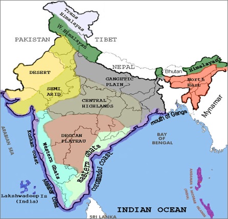
India can be divided into 6 physical divisions which are:
- The Northern Mountains
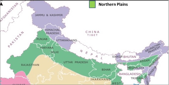
- The North Indian Plain
- The Peninsular Plateau
- Great Indian Desert
- The coastal Regions
- Islands
- Punjab Plains
- Ganga Plains
- Brahmaputra Plains
- Bhabhar
- Tarai
- Khadar
- Bhangar
- It comprises of pebble studded rocks that are highly porous bed plain
- The streams disappear here because of the high porosity
2 Tarai
It lies south of Bhabhar running parallel to it. It is marked by the re-emergence of underground streams of the Bhabhar belt
- Highly alluvial & agricultural land
- It also has a water table because of groundwater percolating down from the adjacent zone
- It is a zone of intensive agriculture
- The soil is non-porous, clayey, and loamy
- The soil of this region is known as kankar (calcareous concretions)
- It is coarse in nature and contains kankar (lime nodules), pebbles, and gravels

The North Indian Plain
These are formed by depositional work by rivers such as Indus, Ganga & Brahmaputra. It is 2400 Km long and its width varies from 240 to approx. 320 km.
It can be divided into three sections which are:
It is formed by the Indus and its tributaries. Major parts of it lie in Pakistan.
It is between Ghaggar and Tista rivers. Haryana, Delhi, UP, Bihar, part of Jharkhand, and West Bengal lie in the Ganga plains.
This plain lies from Tista to Dihang and major parts of it lie in Assam.

The Northern plains can be further divided into the following divisions:
1 Bhabhar
It lies from Indus to Tista, along the foothills of Shivalik. It is laid down by the streams coming from the hills.
3 Khadar
These are flood plains with newer alluvium deposited by flood almost every year and have very fertile soil.
4 Bhangar
It is an alluvial terrace lying above the level of flood plains and composed of the oldest alluvial soil.

Share:


Comments
Waiting for your comments